
From the Pathfinder Collection:
By Jennifer Moragoda
Made by Terry
In the 1950s and early 1960s, Terry Jonklaas was Ceylon’s most fashionable and sought-after interior designer. To own a piece of furniture “made by Terry” was to signal modern taste, affluence and social standing. Affluent families commissioned him to furnish the home of a newly married daughter; others acquired a single piece of furniture or a decorative object from his Galle Face Court showroom. Commercially astute, he offered different points of entry while preserving the exclusivity of his name, translating his personality into objects, interiors and a distinctive way of living. Yet this once-famous designer has largely disappeared from Sri Lanka’s history of modern design, even as many of his objects—and the forms he helped popularize, widely imitated from the outset—remain hidden in plain sight.
The Decorators and Furnishers, which Jonklaas headed at No. 1 Galle Face Court, became synonymous with innovative design, fine materials, exceptional workmanship and high prices. Its furniture and imported European glassware and tableware carried considerable social cachet. One grandson recalls his grandmother, whose residence Jonklaas had custom-furnished, becoming anxious whenever he and his brother did their homework at her dining table, fearing they might scratch its teak surface. In another family, a son remembered how unfamiliar Jonklaas’s designs seemed beside the traditional furniture his mother had inherited. After purchasing a modern living-room ensemble, she would proudly inform visitors that the settee on which they were about to sit was a Terry Jonklaas creation.


The world he inherited
Terence Powell “Terry” Jonklaas was born in Kandy in 1919 and boarded at St. Thomas’ College, Mt. Lavinia, from the age of nine. He excelled at English, swimming and diving, though he “disliked school intensely,” calling it “a journey to another planet.” The youngest of six brothers, ten years younger than the next eldest, he developed a playful, irreverent streak.
Terry Jonklaas belonged to the tenth generation of an established Dutch Burgher family that could trace its ancestry in Ceylon to the earliest Dutch arrivals in the seventeenth century. His family had been based in Kandy for at least two generations and was firmly embedded in the colonial establishment; its members included eminent lawyers, civil servants and planters. This background matters less as genealogy than as an indication of the social position he inherited and the cultural assumptions it fostered. His secure place within this established milieu contrasts with the more hybrid identities of Minette de Silva and Geoffrey Bawa, for whom questions of cultural belonging became more explicit professional concerns.
His maternal cousin George Keyt, a founding member of the ’43 Group, was likewise raised in Kandy and was about ten years older. Between 1946 and 1949, Jonklaas was invited to exhibit with the ’43 Group as a guest artist in four exhibitions, receiving mixed but sometimes revealing notices. One critic detected “a definite bias for the macabre and a certain cynicism,” while another described his technique as “bold and carefree.”
A large oil painting by Jonklaas of a male and female nude still hangs above the bar he designed for his close friend Sir John Kotelawala at Kandawala. It may be The Lovers, listed in the catalogue of the 1946 exhibition.
The catalogue for the ’43 Group’s 1947 exhibition also contains the earliest reference so far located to The Decorators and Furnishers, listing “WOOD CARVINGS by Decorators and Furnishers.” Jonklaas later placed prominent advertisements in ’43 Group exhibition catalogues and in the catalogue for Aubrey Collette’s 1955 Faces exhibition.
After a short stint at the Times of Ceylon as a cub reporter, he joined the Ceylon Tobacco Company, which sent him to Central Java, where he remained until war appeared imminent. He later spent two years at Edwards, Reid & Begg, although the nature of his training there remains unclear.
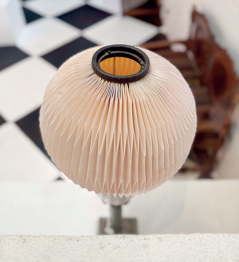
A pleated Le Klint lampshade at Lunuganga. The Danish firm’s lighting was sold by The Decorators and Furnishers from 1957. (Photo: Jennifer Moragoda)
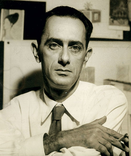
Terry Jonklaas, MBE, interior designer, at work, 1950. (Courtesy of The Observer)
By at least 1947, Jonklaas had established a considerable reputation. Thilo Hoffmann recalled that, after his marriage, he and his wife moved into their first home, a small flat in the Baurs building. It was barely furnished, apart from a few pieces designed by Jonklaas, whom Hoffmann described as “a then leading designer.” By 1951, Jonklaas had been admitted as a Member of the Society of Industrial Artists (SIA), Britain’s first professional body for designers. In 1956, aged thirty-six, he was appointed a Member of the Order of the British Empire (MBE) for his work in interior design.
The business of modern living
Jonklaas served as managing director of The Decorators and Furnishers, founded in 1947. He was its creative engine and public face—in effect, the brand itself. His partners provided the financial backing, connections and social imprimatur needed to sustain the enterprise. Sir Chittampalam Gardiner was chairman, while R. P. Senanayake, N. Sellamuttu, S. Sellamuttu, Sellamuttu Somasunderam and Kurban Adamally served as directors. Notably, the company was the only Ceylonese design firm to be a member of the Design and Industries Association of Great Britain.
Jonklaas travelled regularly to European design exhibitions, including the Milan Triennale, where he cultivated relationships, secured sole agency agreements with prestigious firms and kept abreast of new products, forms and materials.
Many remember visiting the showroom at No. 1 Galle Face Court, whose broad frontage displayed Jonklaas’s furniture alongside contemporary European lighting, glass, tableware and gifts. Modernity could be viewed through the window before it was purchased for the home. Manik de Silva recalled furniture unlike anything he had seen, while Shanth Fernando remembered a black metal vase lacquered orange inside, Clancy glass, Lalique, Steuben and Jonklaas chairs with brass-tipped legs; his mother once had one of the designer’s cane chairs copied.
For contemporary readers, Jonklaas’s influence might be compared—despite differences in period and design vision—to that of Shanth Fernando and Paradise Road. Each changed the visual culture of domestic life in Sri Lanka, making a new form of contemporary living desirable and recognizable. Jonklaas gave material form to the relaxed sociability emerging around Independence: a pre-air-conditioned world of home bars, dining rooms, verandahs and gardens, clubs, race meetings and entertaining, where growing informality coexisted with rituals of dress, status and display.
The Decorators and Furnishers became a destination for prestigious wedding gifts and introduced Ceylonese buyers to European lighting, glass, ceramics and tableware. At a time when interior design was only beginning to emerge as a distinct profession, Jonklaas designed furniture, lighting and furnishings; worked with timber, cane, metal, glass and new industrial materials such as rexine, plastics and Formica; and undertook commissions for offices, exhibitions, kitchens and entire houses. His customized pieces and recurring design flourishes were tailored to the personalities and social lives of his clients.


The interiors he designed for Mubarak Thaha offer a vivid example. Thaha was a well-known figure with interests in Colombo clubs and horse-race betting. The eight-foot-long bar occupied the space beneath a staircase. Nearby stood elongated swivel chairs with moulded high backs, upholstered in saffron-yellow corduroy and supported on cast-iron pedestal bases, alongside locally made interpretations of the Barcelona chair. The imposing curved bar was faced with panels of speckled Formica edged in brass; a brass foot rail ran along its base, while the countertop, raised on recessed iron supports, appeared to float above the structure. The bartender’s side was as carefully resolved as the public face, with finely finished solid-teak carpentry. As a final flourish tailored to the owner, Jonklaas designed a plaster-of-Paris horse’s head for the counter-top.
The commission shows how he combined materials, function and character to create an interior suited to the life of the room and the personality of its owner. His advertising was equally integral to the enterprise: in newspapers and exhibition catalogues, Jonklaas’s name received billing equal to that of the firm.
The Jonklaas idiom
Jonklaas’s furniture belonged confidently to international post-war modernism, part of a wider shift away from ornately carved antique furniture that evoked walauwa living and claims to pedigree, status and tradition.
He introduced a lighter, more informal sensibility in which form, proportion and material took precedence over applied ornament. Wall-mounted construction, slender recessed legs, metal stems, splayed supports, rounded corners, cantilevered tops and thin profiles made many pieces appear to float. Sideboards, cabinets, tables and upholstered furniture shed visual weight, allowing space to flow beneath and around them. Curves softened their volumes, while meticulous finishes and the grain of Burma teak, naedun, tamarind, jak, satinwood and ebony provided richness and distinction.
His work drew more strongly on an international modernist vocabulary than on recognizably traditional Ceylonese forms. Yet this break with traditional form did not mean a break with traditional skill. His designs depended upon Ceylonese carpenters, furniture makers, cane-workers, brass workers and ironsmiths, who translated modern ideas into finely finished workshop-made objects.
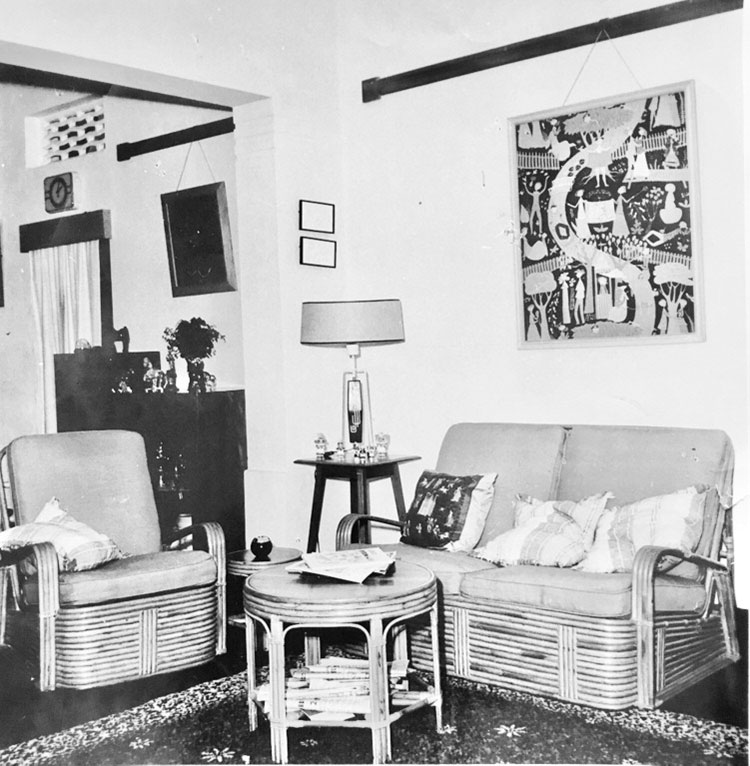
Cane ensemble designed by Jonklaas for Aubrey Collette in the 1950s. (Courtesy of Cresside Collette)
His originality lay in how he made post-war modernism his own: through combinations of local and imported materials, exceptional craftsmanship, practical ingenuity and humour. Machine-made brass-plated edging and industrial fittings became decorative details, while his trademark brass “socks,” capping conical legs, were widely copied. Formica faced bars and sideboards; coloured glass slag was used in garden lanterns; tiles enlivened table surfaces; and imported glass shades became complete lighting designs through locally made fittings.
The limitations of available materials and small workshops often encouraged invention. Jonklaas substituted cast iron for industrially produced chrome and steel, and repurposed ordinary metal washers as feet beneath splayed chair and table legs. Swivel chairs were created by mounting the seat on a central rod inserted into a hollow base.
A teak dressing cabinet designed for N. U. Jayawardena’s Cambridge Place house demonstrates Jonklaas’s fine finishes and playful ingenuity. Closed, its sleek fluted facade and elongated brass handles form a solid floating block. Opened, mirror-faced doors frame a central mirror and reveal a working surface with drawers and a concealed compartment below. The compartment revolves through 180 degrees, bringing its contents within reach before returning them neatly out of sight. A small round stool on castors can be parked beneath the cabinet. Like much of Jonklaas’s best work, it is playful and beautiful, yet governed by function and economy of space.
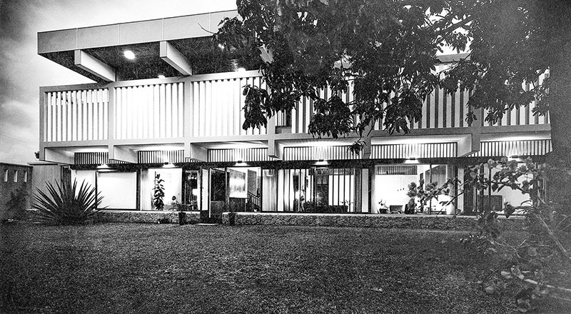
N. U. Jayawardena’s Cambridge Place house, designed by Ulrik Plesner, 1959–60. (Courtesy of Ismeth Raheem)
His irreverent, slightly perverse humour is captured in a pair of ceramic salt-and-pepper shakers from a series he designed for the Danish company A/S Rafa and sold under its Nymølle brand. Two complementary conical forms become hooded monks in cassocks, their toes peeking from beneath their robes. Their shapes allow them to be arranged in different configurations: seen in profile, they appear to proceed solemnly to Mass; only when turned to face the viewer are their true characters revealed. One hunches forward with clasped hands and a disapproving frown; the other, with shifty eyes, sniggers. The joke continues in their use: each figure must be grasped by the neck, inverted and shaken to dispense the salt or pepper.
Modernism at ease
Cane and rattan, comparatively affordable materials, offered another expression of relaxed living and entertaining. Jonklaas helped make cane furniture respectable enough to move from the verandah into the drawing room. The ensemble he designed for his friend Aubrey Collette in the 1950s is a particularly elegant example: thick bands of rattan wrap around the settee and armchairs, forming their bases in place of conventional legs.
The now-ubiquitous leather-and-cast-iron butterfly chair offers another example of Jonklaas’s role in popularizing modern designs. Sharya Scharenguivel, daughter of his client and close friend Chloé de Soysa, recalled that within their circle it was known as the “Jonklaas chair.” Created in Buenos Aires in 1938 and copied worldwide, it became associated in Sri Lanka with Geoffrey Bawa and Ulrik Plesner through published photographs of their interiors. Jonklaas’s possible role in its local circulation is less known. Today, inexpensive versions are sold along the Kandy Road, their popularity owing to their comfort and ease of fabrication.
Furniture finds its architecture
Jonklaas’s furniture found perhaps its most perfect architectural setting in N. U. Jayawardena’s Cambridge Place house, built in 1959–60. Designed by the Danish architect Ulrik Plesner, it was radically modern for Colombo: a rectilinear, strongly horizontal structure with grass-covered roof terraces at a time when pitched roofs were still the norm. The upper storey appeared almost to float above a transparent ground floor, where a broad bank of teak-framed sliding glass doors opened directly onto the garden, revealing the carefully integrated interiors.
The commission brought Jonklaas into contact with an architect who possessed an unusually intimate understanding of furniture and craftsmanship. Plesner had apprenticed in carpentry during his education in Copenhagen and was the stepson of Kaare Klint, a foundational figure in modern Danish furniture design.
During the same period, Jonklaas also designed most of the furniture ensembles for Aelian Kannangara’s residence, designed by Geoffrey Bawa. Its architecture bears striking affinities with the Cambridge Place house.
Hidden in plain sight
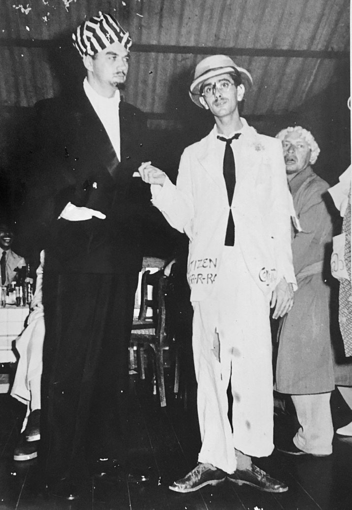
Terry Jonklaas as Citizen Perrra and Aubrey Collette as Mandrake the Magician at Havelock Golf Club. (Courtesy of Cresside Collette)
Jonklaas’s Ceylonese career lasted barely 16 years, from about 1947 to 1963. His interiors and furniture were seldom systematically documented, while ensembles in private houses were divided among descendants or dispersed through auction, often losing their provenance. Yet the simple silhouettes, teak and rattan, and relaxed informality he helped make acceptable have returned to fashion. His pieces blend seamlessly into contemporary settings even as their authorship remains largely unrecognized.
The last cocktail party
The loss of Jonklaas’s name followed the dispersal of the social world that had sustained it.
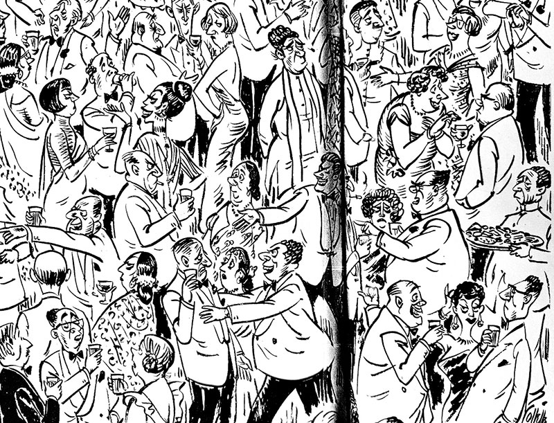
Aubrey Collette, My Very Last Cocktail Party, c. 1961. (From The Times of Ceylon)
He was remembered as gregarious, approachable and mischievous. Very tall and fair, he was an immediately recognizable presence. He bonded with clients over gardens, entertaining, travel and antique hunting, and many were or became close friends. Friends recalled his practical jokes, including an occasion when he scattered vegetables just inside the entrance gate of Cecil and Chloé de Soysa’s home; the family immediately knew who was responsible. He moved easily among prominent Burgher, Sinhalese, Tamil and Bohra families.
These networks were essential to an interior designer whose work depended upon trust and the willingness of clients to admit him into the intimate process of making a home. Access to them, however, was often restricted by class, ancestry and family standing.
One of his closest friends was Aubrey Collette, Ceylon’s best-known political cartoonist and caricaturist. In a photograph taken at a fancy-dress party, Jonklaas appears in a shabby white suit bearing the name “Citizen Perrra,” while Collette is dressed as Mandrake the Magician—both characters from Collette’s cartoons. Jonklaas’s pose captures his position within society: a carefree participant, performer and amused observer.
Collette recognized, as did many around him, that this confident social world was nearing its end. In My Very Last Cocktail Party (c. 1960), he turned Colombo’s fashionable social set into a densely packed satire: British residents and members of the Ceylonese elite mingle as jaded, self-satisfied or faintly condescending figures, while a man in national dress stands visually apart. The old order, shaped by colonial privilege and sustained by narrow networks of class, language and family, could no longer assume its permanence.
This world should not be recalled only through nostalgia. Its intimacy, ease and cultural sophistication coexisted with exclusions and inequalities long ignored by those whom the system served. Political change widened access to power and altered the composition of social and professional networks, although it did not eliminate the importance of personal connections.
Collette left Ceylon in 1961. Jonklaas followed with his family in 1963 and continued working as a designer in Australia. For them, as for many Burghers of their generation, Australia offered another future as the assumptions governing their place in Ceylon began to change.
The last cocktail party was over. The friends dispersed, the houses passed to new owners, and the carefully assembled interiors were divided and sold. The name that had once guaranteed excitement, prestige and modernity gradually faded.
Yet the objects remain: a bar cabinet with intricate marquetry, a teak table floating above an iron frame, a brass-capped leg, a revolving drawer, a cane settee or a pair of mischievous monks. Through them, Jonklaas’s interiors—and Terry Jonklaas himself, once a household name—can begin to be seen again.
from The Island https://ift.tt/z0NfqSB

